We want to be able to define a task with waypoints, a start time, and set weather, ideally in a secure way.
Then sim pilots in real-time, or individually, can fly those tasks and record completion times that are comparable.
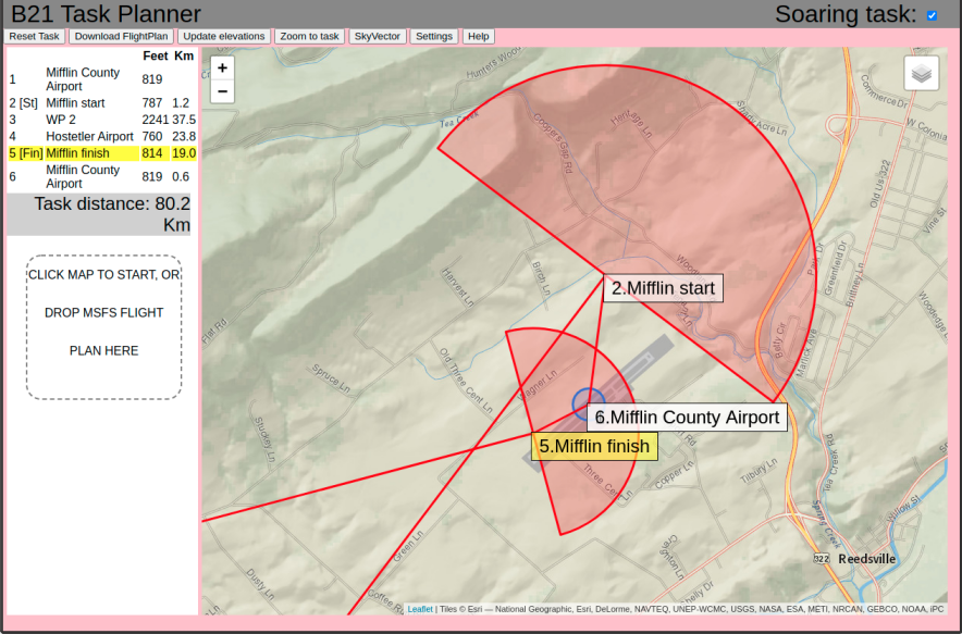 B21 Task Planner is particularly designed for soaring tasks (in MSFS), and
is accessible simply by visiting the web page. The [Help] button in the app provides a good introduction to the
program, and the usage is designed to be as simple as possible.
B21 Task Planner allows you to set optional additional parameters for each waypoint, such as elevation, radius,
max/min altitudes, and these will be recognised by B21 soaring nav instruments and ignored by other aircraft.
B21 Task Planner is particularly designed for soaring tasks (in MSFS), and
is accessible simply by visiting the web page. The [Help] button in the app provides a good introduction to the
program, and the usage is designed to be as simple as possible.
B21 Task Planner allows you to set optional additional parameters for each waypoint, such as elevation, radius,
max/min altitudes, and these will be recognised by B21 soaring nav instruments and ignored by other aircraft.
Mission-X is a plugin for X-Plane than supports the creation of scripted missions. I'm not aware of it being used for soaring tasks but it is worth a look.
Tasks should be stored in the X-Plane FMS format
Little Navmap (Windows, Mac, Linux) is a good flight planning tool.
Plan-G (Windows) is a good flight planning tool.
Soaring waypoint lists can be converted into comma-separated '.csv' format and loaded into Little Navmap. The Little Navmap manual describes the process and required format of the csv file.
In a nutshell, for soaring waypoints, the simplest list of columns for the CSV file would be:
"Pin",,<ident>,<lat>,<lon>,<alt>,,,<description>
Note this list includes 3 blank columns (will be explained later).
"Pin" tells Little Navmap to use a pin symbol for the waypoint. The manual lists alternatives such as "POI".
ident should be a 6-character-max string identifying the waypoint, without spaces.
lat, lon, alt are the position of the waypoint in decimal degrees and feet.
description is free text describing the waypoint, which most usefully can be the name followed by a location description.
For example, here is the line refering to the Ripon Cathedral turnpoint:
Pin,,Ripon,54.1350833,-1.5206167,102,,,Ripon - Cathedral Tower
The Little Navmap omitted columns (e.g. between "Pin" and "Ripon" above) are name, magnetic offset and user tags respectively. The reason to omit the 'name' is that it clutters the map.
Credit Dempsey
All X-Plane aircrafts have an FMC (visible or not) into which your can upload an FMS plan. For example the Cessna 172 has a GPS430 with very primitive capabilities, but in the back ground there is an FMC that can direct the GPS430.
...more coming soon...